Answer the question
In order to leave comments, you need to log in
What program can create a map of the area with subsequent export to tiles?
Good afternoon, is there any software that could be used to create a map of the area, for example, by tracing it using satellite images?
And at the output, you need to be able to save as tiles in 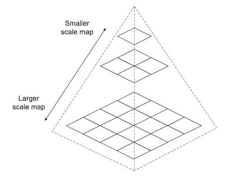
such a way that, depending on the zoom, certain drawn objects were displayed differently
T. e. the farther from the map, the easier the detailing of certain objects, the closer the more detailed, the lines are thicker, text descriptions, some additional ones appear
Answer the question
In order to leave comments, you need to log in
QGIS + QTiles - if you indulge;
Mapnik + PostGIS - if you want to create something serious.
Didn't find what you were looking for?
Ask your questionAsk a Question
731 491 924 answers to any question