Answer the question
In order to leave comments, you need to log in
How to visualize distances with Python?
Good afternoon!
Tell me, please, if there are any ready-made solutions or give a kick in the right direction to solve the next problem.
Given a map of Russia, objects of two types are set on the map: bases and points. When you click on the base, you need to get the distances to all points and visualize the relationship between objects using lines. Accordingly, each line corresponds to a certain distance, which also needs to be reflected on the map and which is stored in an array like a table of distances between stations 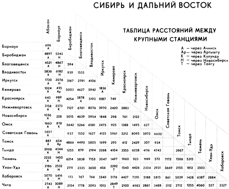
:
And yes, I haven’t read DEVELOPMENT OF GEOAPPLICATIONS IN PYTHON LANGUAGE yet, I still want to reach the most ready-made solution.
Answer the question
In order to leave comments, you need to log in
Since you are considering the Yandex / Google Maps API, the task here is more about JavaScript, not Python. See the Maps API documentation . Draw points , on click event - draw lines , everything is pretty trivial. Don't count on a ready-made solution.
But here, after all, there is no dynamics; everything is known in advance why the Yandex and Co. API is needed. It is quite possible to get by with python + qgis, since you really want a python. Draw everything at once in a shape-file and simply select the necessary segments depending on the selected station.
Didn't find what you were looking for?
Ask your questionAsk a Question
731 491 924 answers to any question