Answer the question
In order to leave comments, you need to log in
How can I pull out and from where a map of Moscow and the region with a division into territorial boundaries in SVG?
Greetings
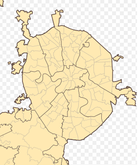
There is a need to get a map of Moscow and the Moscow region in SVG with a division into territorial boundaries of populated punctures (districts, cities, regions, towns, villages). There should be something similar to this:  but for the required area. I found a map of Moscow in SVG with division into districts easily, but with a map of the Moscow region everything is difficult, of course it is in SVG, but only with the main areas, but a map with division into smaller elements "by day with fire" can not be found.
Please tell me how and where can I get such a card.
Answer the question
In order to leave comments, you need to log in
1. Download Openstreetmap data in pbf format from here: gis-lab.info/projects/osm_dump
2. Raise PostGIS.
3. Upload the dump to PostGIS via osm2pgsql (with default settings)
4. Run QGIS, connect to the planet_osm_polygon table in it, make the filter "admin_level IS NOT NULL"
5. Set up styles in QGIS - colors, line thickness, order, and filtering - what admin_level do you need.
6. Create a new layout in QGIS, add a map to the layout in composer, move it to the desired coverage, export to svg.
Didn't find what you were looking for?
Ask your questionAsk a Question
731 491 924 answers to any question