Answer the question
In order to leave comments, you need to log in
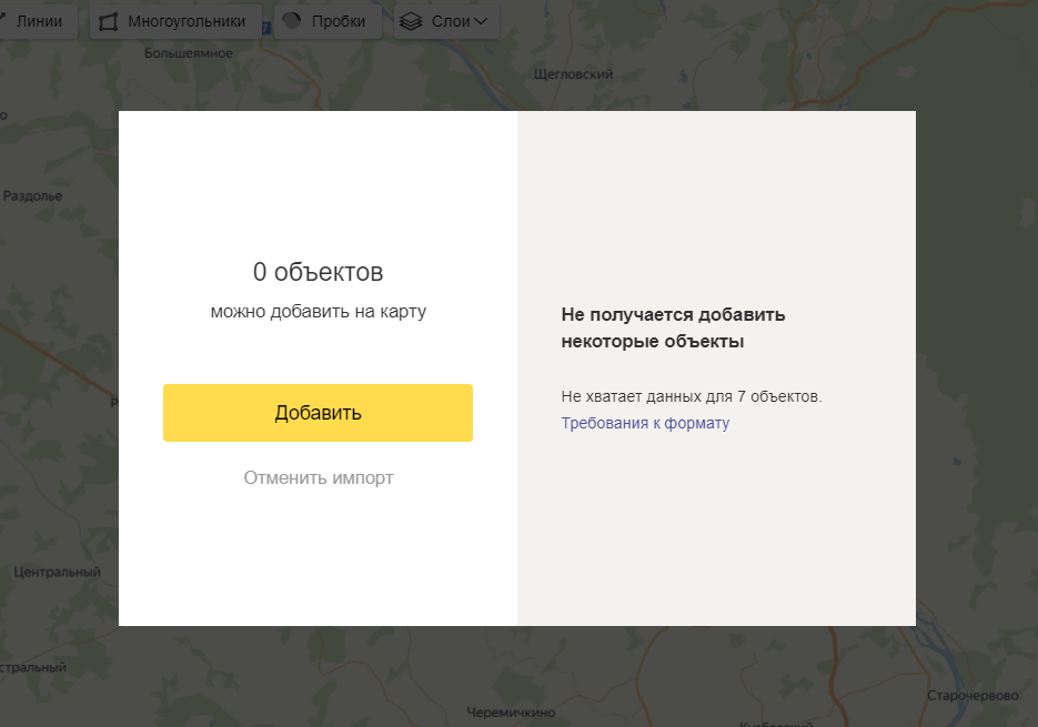
I can not import the geojson file on Yandex maps. What is the problem, does anyone know?
There is a ready-made file, you need to import it to the map, but there is a problem when importing. 
The file itself must not be broken, which is the problem I can not understand, perhaps Yandex has its own criteria that are not met.
Here is the code.
{
"type": "FeatureCollection",
"name": "buildings",
"crs": { "type": "name", "properties": { "name": "urn:ogc:def:crs:OGC:1.3:CRS84" } },
"features": [
{ "type": "Feature", "properties": { "floor": "4", "street": "Советский", "home": "29" }, "geometry": { "type": "MultiPolygon", "coordinates": [ [ [ [ 86.06914303965705, 55.3589648015545 ], [ 86.069323367440305, 55.358923671209354 ], [ 86.069326992978631, 55.358928791339508 ], [ 86.069837257486753, 55.358810526540204 ], [ 86.069760235659032, 55.358702900674153 ], [ 86.069252400721368, 55.358820138159068 ], [ 86.069252708881038, 55.358820702538978 ], [ 86.06906993721104, 55.358863892835906 ], [ 86.06914303965705, 55.3589648015545 ] ] ] ] } },
{ "type": "Feature", "properties": { "floor": "5", "street": "Ноградская", "home": "2" }, "geometry": { "type": "MultiPolygon", "coordinates": [ [ [ [ 86.068421540827174, 55.357963058102015 ], [ 86.068667973336588, 55.358307222851096 ], [ 86.068875905773041, 55.358258690383785 ], [ 86.068742874650241, 55.358070613831416 ], [ 86.068711031095134, 55.35807834289146 ], [ 86.068684477298532, 55.358040845867585 ], [ 86.069324705055948, 55.357892561384865 ], [ 86.069356666243237, 55.357937235598079 ], [ 86.069534260751453, 55.357896064499947 ], [ 86.069418363040143, 55.357731609054746 ], [ 86.068421540827174, 55.357963058102015 ] ] ] ] } },
{ "type": "Feature", "properties": { "floor": "6", "street": "Кузнецкий", "home": "32" }, "geometry": { "type": "MultiPolygon", "coordinates": [ [ [ [ 86.068929713527197, 55.358370419390454 ], [ 86.068742276498526, 55.358415698163832 ], [ 86.069062300782662, 55.358865655101688 ], [ 86.069251201883546, 55.358822183098638 ], [ 86.068929713527197, 55.358370419390454 ] ] ] ] } },
{ "type": "Feature", "properties": { "floor": "5", "street": "Советский", "home": "33" }, "geometry": { "type": "MultiPolygon", "coordinates": [ [ [ [ 86.071199769648615, 55.357833308307455 ], [ 86.071274408200892, 55.357934423763041 ], [ 86.071352304751372, 55.357917169380102 ], [ 86.071609824815965, 55.358280558901484 ], [ 86.071550762752622, 55.358294235054245 ], [ 86.071538747282119, 55.358277649886681 ], [ 86.071204380578465, 55.358355385471654 ], [ 86.071289576490045, 55.358474602384305 ], [ 86.07189575682672, 55.358336497288512 ], [ 86.071491775255154, 55.357766597223367 ], [ 86.071199769648615, 55.357833308307455 ] ] ] ] } },
{ "type": "Feature", "properties": { "floor": "3", "street": "Ноградская", "home": "4" }, "geometry": { "type": "MultiPolygon", "coordinates": [ [ [ [ 86.069657661309563, 55.357866253829279 ], [ 86.069734489702213, 55.357973728020994 ], [ 86.070245876493942, 55.357854458867806 ], [ 86.070168343754503, 55.357747401664838 ], [ 86.069657661309563, 55.357866253829279 ] ] ] ] } },
{ "type": "Feature", "properties": { "floor": "4", "street": "Ноградская", "home": "6" }, "geometry": { "type": "MultiPolygon", "coordinates": [ [ [ [ 86.070177617136054, 55.357554707796702 ], [ 86.070296815121722, 55.357718274936232 ], [ 86.070473188971704, 55.357677836077755 ], [ 86.070442064398421, 55.357633292758436 ], [ 86.07108301254074, 55.357485543399235 ], [ 86.071107305249825, 55.357520428192124 ], [ 86.071074811674109, 55.357527864661179 ], [ 86.071208768320943, 55.357717092885167 ], [ 86.071418972117797, 55.357669020914585 ], [ 86.071176789289026, 55.357327741967936 ], [ 86.070177617136054, 55.357554707796702 ] ] ] ] } },
{ "type": "Feature", "properties": { "floor": "6", "street": "Советский", "home": "31" }, "geometry": { "type": "MultiPolygon", "coordinates": [ [ [ [ 86.069898215564706, 55.358604094998547 ], [ 86.070016959595748, 55.358769820431995 ], [ 86.070409174569974, 55.35867902036761 ], [ 86.071013012386331, 55.358538892204827 ], [ 86.070897335671262, 55.358372910037986 ], [ 86.070717160454564, 55.358415506116216 ], [ 86.070747010414479, 55.358459121477459 ], [ 86.070109078283778, 55.358606198399059 ], [ 86.070078921212087, 55.358561012459546 ], [ 86.069898215564706, 55.358604094998547 ] ] ] ] } }
]
}Answer the question
In order to leave comments, you need to log in
run the file for validity - geojsonlint.com
recommend crs to remove and observe the sequence of polygon points .
An example file for YAK can be downloaded by clicking on the link: GeoJSON file example .
Didn't find what you were looking for?
Ask your questionAsk a Question
731 491 924 answers to any question