Answer the question
In order to leave comments, you need to log in
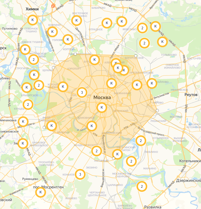
How to hide labels and clusters outside of a polygon?
Good evening.
I tried to google, but the search was a failure.
Please help.
There is a map with markers (of type Placemark) and clusters and a polygon that the user draws: You

need to hide all markers and clusters outside the drawn polygon.
Labels, clusters and polygon are generated as follows:
clusterer = new ymaps.Clusterer({
            preset: 'islands#darkOrangeCircleIcon',
            clusterIconColor: '#ffbe31',
            groupByCoordinates: false,
            clusterDisableClickZoom: true,
            clusterHideIconOnBalloonOpen: false,
            geoObjectHideIconOnBalloonOpen: false,
            clusterBalloonContentLayout: customBalloonContentLayout
        }),
            getPointData = function (index) {
            return {
                balloonContentHeader: ' ',
                balloonContentBody: flat,
            };
        },
            getPointOptions = function () {
            return {
                iconLayout: circleLayout,
            iconShape: {
                type: 'Circle',
                coordinates: [0, 0],
                radius: 21
            },
            };
        },
        points = [
            [55.831903,37.411961], [55.763338,37.565466], [55.763338,37.565466], [55.744522,37.616378], [55.780898,37.642889], [55.793559,37.435983], [55.800584,37.675638], [55.716733,37.589988], [55.775724,37.560840], [55.822144,37.433781], [55.874170,37.669838], [55.716770,37.482338], [55.780850,37.750210], [55.810906,37.654142], [55.865386,37.713329], [55.847121,37.525797], [55.778655,37.710743], [55.623415,37.717934], [55.863193,37.737000], [55.866770,37.760113], [55.698261,37.730838], [55.633800,37.564769], [55.639996,37.539400], [55.690230,37.405853], [55.775970,37.512900], [55.775777,37.442180], [55.811814,37.440448], [55.751841,37.404853], [55.627303,37.728976], [55.816515,37.597163], [55.664352,37.689397], [55.679195,37.600961], [55.673873,37.658425], [55.681006,37.605126], [55.876327,37.431744], [55.843363,37.778445], [55.875445,37.549348], [55.662903,37.702087], [55.746099,37.434113], [55.838660,37.712326], [55.774838,37.415725], [55.871539,37.630223], [55.657037,37.571271], [55.691046,37.711026], [55.803972,37.659610], [55.616448,37.452759], [55.781329,37.442781], [55.844708,37.748870], [55.723123,37.406067], [55.858585,37.484980]
        ],
        geoObjects = [];

    for(var i = 0, len = points.length; i < len; i++) {
        geoObjects[i] = new ymaps.Placemark(points[i], getPointData(i), getPointOptions());
    }

    clusterer.options.set({
        gridSize: 80,
        clusterDisableClickZoom: true
    });

    clusterer.add(geoObjects);
    myMap.geoObjects.add(clusterer);

let myPolygon = new ymaps.Polygon([], {}, {
        // Курсор в режиме добавления новых вершин.
        editorDrawingCursor: "crosshair",
        // Максимально допустимое количество вершин.
        editorMaxPoints: 7,
        // Цвет заливки.
        fillColor: '#ffbd42',
        fillOpacity: 0.3,
        // Цвет обводки.
        strokeColor: '#ffc354',
        // Ширина обводки.
        strokeWidth: 2,
        draggable: true
    });
    // Добавляем многоугольник на карту.
    myMap.geoObjects.add(myPolygon);

    // Включаем режим редактирования с возможностью добавления новых вершин.
myPolygon.editor.startDrawing();Answer the question
In order to leave comments, you need to log in
Didn't find what you were looking for?
Ask your questionAsk a Question
731 491 924 answers to any question