Answer the question
In order to leave comments, you need to log in
How to get coordinates stored in OSM(PostgreSQL with PostGIS)?
Hello, I am raising the tracking and monitoring service for a taxi. I do it for the first time. It is very difficult to search for information, due to the fact that so far I am poorly versed in geolocation issues.
The essence of the question is as follows - there are coordinates that are stored in a locally raised database where the city was previously imported (osm2pgsql). The planet_osm_nodes table looks like: 
But, I could not determine the coordinate format. 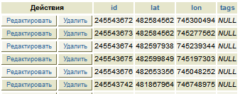
What is the format and how to convert the data back, well, or give a link to understand how it works. Thank you in advance.
Answer the question
In order to leave comments, you need to log in
planet_osm_nodes is a by-product of osm2psql. You need the planet_osm_point label for point features. The geometry is stored in the way field in postgis format.
Didn't find what you were looking for?
Ask your questionAsk a Question
731 491 924 answers to any question